NOAA ITOS High Resolution Picture Transmission (HRPT)
The NOAA ITOS (Improved TIROS Observation Satellite) series of satellites transmit high resolution pictures from the VHRR (main radiometer) and calibration/telemetry data over an analog HRPT link. Additionally, the same signal is used to transmit stored data.
The signal is an analog video signal, FMFrequency Modulation modulated, encoded over an FMFrequency Modulation link. The main payload of HRPT is VHRR data composed of two channels in the visible, and infrared spectrum; additionally, telemetry similar to APT is included in the image, and the data are transmitted at 360 lines per minute (LPM).
This signal is not to be confused with the more modern, digital HRPT signal used by the ATN (POES) series of satellites, or with the variant used by Russian METEOR-M satellites.
Data transmitted[edit]
- 2 channels from VHRR radiometer: an infrared and a visible one.
- Calibration data for VHRR channels
- Spacecraft telemetry and monitoring (TLM)
Signal characteristics[edit]
- Right-hand circular polarization
- FMFrequency Modulation modulation encoding an FMFrequency Modulation analog video signal
- 1 MHzMegaHertz (MHz) 10^6 Hz bandwidth
- Transmit power 5 watts
Satellites transmitting HRPT[edit]
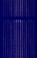
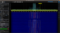
All ITOS satellites are officially decommissioned. However, recently NOAA-2 (ITOS-D) launched over 50 years ago, started transmitting again a signal, that matches the original specifications. No imagery is transmitted, but the telemetry lines are visible.
The signal is on for one minute and off for about two minutes while the satellite is passing, no signal is transmitted at night - furthermore, from Scott Tilley's observations in 2021 on the initial discovery of this satellite being active, it would appear it's rotation or tumble is slowing over time.
"The NOAA 2 spacecraft is tumbling with a period of about 88.6s. The on/off duty cycle is asymmetrical with it on for about ~28s and off for ~61s." Scott Tilley on X detailing signal characteristics in 2021
Last known working reception and decode, was on September 17th, 2025 in Northeast Ohio, USA.
| Satellite | Frequency | Notes |
|---|---|---|
| NOAA 2 (ITOS-D) | 1697.5 MHzMegaHertz (MHz) 10^6 Hz | Only while not eclipsed; no imagery transmitted, only telemetry. |
Baseband recording[edit]
Decoding tutorial[edit]
A note, Xerbo's NOAA-2 GNUradio flowchart seems to be more sensitive and able to pick up the signal than the one by RAD750 on GitHub. If you can find an official link, please add it here.
For better decoding performance, when recording the baseband you should set your SDR to have a noise floor from -80 to -60 dBM and adjust gain to best suit your LNA. The GNUradio decoders very easily lose sync with excessive background noise.
Additional Links[edit]
- File:Noaa 31338.pdf
- Article by Derek OK9SGC about the satellite
- GNU Radio decoder file (see the tutorial above)


